Friday, October 19, 2012

International Geography Olympiad Success

From Scoop (NZ):  International Geography Olympiad Success

In difficult and busy times for the education sector it is always good to have good news, says Professor John Overton. The NZ Geographical Society has received a report on New Zealand successes in the International Geography Olympiad. All four secondary school geographers won medals reports Overton. Their success in 2012 sits alongside those of the five other subjects of the Science Olympiads New Zealand (SONZ); Physics, Chemistry, Biology, Informatics and Mathematics.
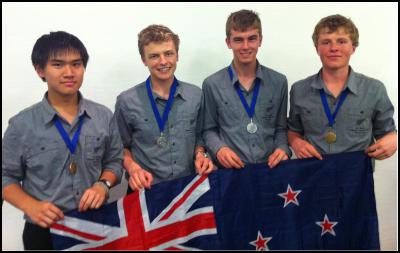
The five day Geography Olympiad was held in Cologne, with three testing examination sessions. Scott Cameron and Brent Coleman from Hamilton Boys High School both won silver medals, with Sidney Wong (Hutt Valley High School) and Connor Clemett (Riccarton High School) getting bronze medals. 34 countries competed, with Singapore the overall winner in 2012.

In a separate team competition the New Zealand poster presentation shared the Dr Prill prize for cartography. The team leader, Anna Wilson from Wellington, reported that the team had written the poster material and trained well for the presentation. She said the team always thought they had a good chance with the theme of well-suited to New Zealand. The theme was “Water as a key national resource”.
Professor Overton acknowledged the work of the teachers who had led New Zealand international teams in Geography since 2006. “They do a great job, and allow our students to be excellent ambassadors for the country, taking our culture and our landscapes to an international audience”. He also noted the value of a government grant that meant students had to raise only about 50% of their fares and participation costs.

New Zealand successes in Cologne. From left, Sydney Wong (Hutt Valley), Scott Cameron and Brent Coleman (Hamilton Boys) and Connor Clements (Riccarton) show off their medals.

Thursday, October 18, 2012

Is geography behind sea-ice paradox?

From The Japan Times: Is geography behind sea-ice paradox?

SINGAPORE — When sea ice covering the Arctic Ocean fell to a record-low level last month, much of the analysis in Asia and the Pacific focused on the opening of new and shorter commercial shipping routes to Europe, and increased access to Arctic offshore oil and gas resources.
These could be very positive developments for the region, especially for the energy-short trading economies of Northeast Asia led by Japan, China and South Korea.
But the dramatic decline in both the extent of Arctic sea ice and its thickness since the start of reliable satellite measurements in 1979 may also signal an alarming acceleration in global warming and climate change caused mainly by burning fossil fuels and clearing forests.
Sea ice is an extensive layer of frozen ocean water that cools the polar zones — the Arctic in the Northern Hemisphere and Antarctica in the Southern Hemisphere. It also helps to moderate the global climate.
Sea ice has a bright surface. As a result, about 80 percent of the sunlight that strikes it is reflected back into space. However, as sea ice melts in the summer, it exposes the dark ocean surface that then absorbs approximately 90 percent of the sunlight. The ocean warms and Arctic temperatures rise further.
Yet there is a seeming paradox between what is happening to sea ice in the Arctic, where it is shrinking fast, and Antarctica, where it has been expanding steadily in recent years.
Climate-change skeptics claim that the growth in Antarctica offsets the retreat of sea ice in the Arctic, demonstrating that nature has a self-righting mechanism. Skeptics question dire warnings from many climate scientists of a warmer world by the end of the century that will set the stage for a long period of catastrophic extreme weather and rising sea levels as the great land-based ice sheets start to melt, first Greenland in the Arctic, and then on a much larger scale in Antarctica.
Research suggests that the two polar zones are reacting differently to measured warming of the atmosphere and seas in both places because of geography. Antarctica is a vast continent encircled by water, whereas the Arctic is an ocean surrounded by exposed land, which reacts more quickly to warming atmospheric temperatures than Antarctica's seas or its thick ice sheets.
Wind and ocean currents around Antarctica isolate it from global weather patterns, keeping it very cold. By contrast, the Arctic Ocean is closely linked with the land climate systems around it, making it more sensitive to change.
Arctic sea-ice loss is cited as one of the most striking and earliest examples of climate change and what it will mean for the future of life on Earth. That it is happening in the Northern Hemisphere, where most of the world's people live, accentuates the potential severity.
The latest polar measurements unveiled by the U.S. National Snow and Ice Data Center (NSIDC) earlier this month showed that Arctic summer sea ice extent reached its lowest point this year on Sept. 16, when it covered 3.41 million sq. km, nearly 3.3 million sq. km below the 1979 to 2000 average.
Ten days later, Antarctica's winter sea ice reached its maximum extent of 19.44 million sq. km, slightly higher than the previous record in 2006. Arctic summer sea ice decline has been far faster than the growth of Antarctic winter sea ice. But the relevant comparison is really summer minimums and winter maximums in each hemisphere.
From 1979-1983 in the Arctic, the summer minimum of sea ice covered an average of just over 51 percent of the ocean. It fell to just 24 percent of the ocean surface this year. In Antarctica, the comparable figures were 13.8 percent and 14.6 percent of the ocean, meaning that summer sea ice shrinkage in the northern hemisphere is greatly outstripping growth in the southern hemisphere.
The same sharp contrast is evident in the winter sea ice maximum of both polar zones between 1979 and 2012. The decline in Arctic winter ice extent is eight times as fast as the increase in Antarctic winter ice.
That still leaves the question why Antarctic sea ice is increasing when local and global temperatures are warming?
Scientists will not know the answers until more research is done. But they think it is partly the result of wind and ocean movements. NSIDC director Mark Serreze also attributes a role to the hole in the ozone layer above Antarctica. He explains that because of this, the stratosphere above Antarctica is very cold.
"Ozone in the stratosphere absorbs UV (ultraviolet) light, and less absorption (by) ozone makes the stratosphere really cold," Serreze says. This cold air descends to the surface, keeping the sea ice extensive.
In the rapidly warming Arctic, the Greenland ice sheet has been melting, leading to substantial net ice loss in recent years. The worry is that if global warming continues on the track predicted by many climate scientists, Antarctica's sea ice and its vast land-based ice sheet will eventually follow.
After all, research has shown that about 52 million years ago, when the concentration of carbon dioxide — the main greenhouse gas from human activity today — was more than twice its current level, Antarctica had palm trees and other tropical vegetation. Summer temperatures on the coast ranged between 20 and 27 degrees Celsius.

Monday, October 15, 2012

Pupils to learn about 200 key British figures from Anglo-Saxons to Winston Churchill as 'politically correct' national curriculum in history is scrapped

From Daily Mail:  Pupils to learn about 200 key British figures from Anglo-Saxons to Winston Churchill as 'politically correct' national curriculum in history is scrapped

History lessons will be rewritten to include 200 key figures, such as Winston Churchill, and events which shaped Britain under a new national curriculum drawn up by education secretary Michael Gove.
The current syllabus, previously attacked for being too politically correct, will be scrapped with the intention of giving children a deeper understanding of history.
Under new plans school children will learn a narrative about British history and key international developments, including the fall of the Roman Empire, the union that created Britain and the decline of its power.
Winston Churchill and Anglo-Saxon monarchs Alfred and Athelstan will also be put on the list of leaders that children will study.
Gove’s blueprint rejects learning by rote, but emphasises that acquiring a detailed knowledge of history will enable children to understand the reasons behind human failures and achievements, The Sunday Times reported.
Secondary school children aged between 11 and 14 will move on to 50 wider topics about the modern world, including Soviet-U.S. relations and how they shaped the world, as well as the influence of immigration on British society.
The national curriculum review was launched in January 2011 but only drafts in primary school maths, English and science have been released.
The new primary and secondary curriculum documents currently being considered cover art and design, citizenship, English, geography, history and physical education.
Headmistress of North London Collegiate school Bernice McCabe, co-director of the Prince’s Teaching Institute and member of the committee advising on the curriculum review, told The Sunday Times: ‘It is not a backward-looking curriculum but very forward-looking.
‘Teachers from the Prince’s Institute have said over the years that there has been a move too much towards skills without sufficient emphasis on the knowledge that you need to use them.
‘In history, for example, we do not see how you can have a good foundation of knowledge without understanding the chronology of events.’
The current version of citizenship, which includes topics such as identities and diversity and how to negotiate, plan and take action has been cut back from 29 pages to one for 11 to 14-year-olds.
The new syllabus will focus on the British monarchy and parliamentary democracy as well as theories on liberty and rights.
In geography, primary children will study physical features, the nature of rocks, rivers and mountains, the names of countries and the characteristics of countries as well as how glaciers shape landscapes.
Later on in secondary school the topics will become more specific, including aspects of human geography, like the industrial expansion of Asia.
Alan Kinder, chief executive of the Geographical Association, advising on the review, told The Sunday Times: ‘ There is concern that pupils…don’t seem to be acquiring the world knowledge that we would expect them to have and most people in the geography subject community feel there needs to be something of a rebalancing.’
It follows criticisms of the current curriculum for failing to ensure children learn about human and physical processed which shape geography.
The PE curriculum is now expected to emphasise the need for physical exertion, amid concerns the current programme requires too little fitness.
The education department refused to comment on the drafts but said they will be made public 'in due course'.


England: Award puts school on map

From Hartlepool Mail:  Award puts school on map 

Clavering Primary School pupils (left to right) Mia, Luke, Ellie-Mae and Duane Clavering Primary School pupils (left to right) Mia, Luke, Ellie-Mae and Duane

A TOWN primary school has been chosen as one of a select few nationwide to receive a prestigious award.
Clavering Primary School, in Clavering Road, Hartlepool, has gained the Geographical Association’s Primary Geography Quality Mark, one of only 51 schools in the country to be handed the award.
The award recognises excellence in the geography curriculum in schools and also acts as a useful tool as it gives teachers access to action plans and learning materials.
Deputy headteacher Neil McAvoy said: “At Clavering we are committed to ensuring quality leadership at all levels and this award very positively reflects on the fantastic work carried out by our geography leader Tamsin Murray.
“She is our geography subject co-ordinator and also leads on a variety of other geography-related aspects of our wider curriculum such as our eco-school work, gardening projects and our outdoor learning zone.” Miss Murray said: “Geography is an essential part of our child-centred approach to learning and plays an important role in our vision to develop imagination, creativity, citizenship and an awareness of the world around us, leading to a thirst for knowledge and an interest in exploration.”
The award is the latest boost for the school, which has recently celebrated receiving Fairtrade school status and the full International School Award, as reported in the Hartlepool Mail last week.


Thursday, October 11, 2012

Knox, research pioneer in streams and soils, dies

From University of Wisconsin-Madison:  Knox, research pioneer in streams and soils, dies

Jim Knox, 70, Evjue-Bascom professor emeritus of Geography at the University of Wisconsin-Madison, died at his home in Madison on Saturday, Oct. 6. Although he had retired in 2011, he continued to work in Science Hall.
Photo: Jim Knox
Knox
A memorial service will take place on Friday, Oct. 12 at noon, with a visitation beginning at 10 a.m., at Cress Funeral Home, 3610 Speedway Road.
During his 43 years as a faculty member at UW-Madison, Knox’s research transformed the field of fluvial geomorphology (studying streams and the landforms they produce), opening new avenues that linked his field to broader contemporary environmental issues. To tens of thousands of students, he was a much-loved teacher, explaining not only how streams and soils work, but why we should care about them.
“I first met Jim when I was a new Ph.D. student on a field trip through southwestern Wisconsin on a cold, early spring weekend,” recalls Matt Kuchta, now an assistant professor of geology physics at UW-Stout, in a remembrance on his blog. “He had so much to share [that] he would talk to both vans via the walkie-talkie. He spent so much time talking about the rivers and fluvial history of the area [that] he ended up draining the batteries in the walkie-talkie more than once. . . His work on the impact of humans on river systems continues to shape the work that I do now.”
The hills and valleys of Wisconsin’s Driftless Area served as Knox’s “laboratory.” He carried out his best known work near the Grant County farm where he grew up, inspired by the winding streams and the glacial history of the Quaternary Period.
“At a gathering last year to commemorate Jim’s career, former graduate students often turned to descriptions of Jim enthusiastically surveying stream channels in the Driftless Area, in cold, wet weather or fading light,” says Joe Mason, professor of geography. “In recent decades, he told me, he often helped his brother with work on the family farm, once noting that he had gone from putting up hay one afternoon to sitting on a National Science Foundation advisory panel in Washington the next day.”
James C. Knox was born in Platteville on Nov. 29, 1941. His early experiences made him a firm believer in the Wisconsin Idea, and in the value of research and teaching at the University of Wisconsin to the people of the state. After earning degrees from UW-Platteville and the University of Iowa, he came home to Wisconsin to take a faculty position at UW-Madison in 1968.
“As his colleagues, we knew him as a model citizen of his department, university and profession. He was always willing to dedicate his time, good nature and common sense to work for the greater good.”
Joe Mason
Knox’s best-known research was on the sometimes-dramatic changes in the magnitude and frequency of floods and the behavior of streams in general. His widely cited 1993 paper in the journal Nature demonstrated that, over the past several thousand years, even modest changes in climate caused large changes in the frequency of large floods along Driftless Area streams. To detect the effects of land use change, he used metal contamination from 19th century lead and zinc mining as a tracer, showing that the rates of soil erosion and sedimentation on floodplains increased dramatically as forest or prairie was turned into farmland.
Knox also played an important role in encouraging the developers of climate models to compare their simulations of past climates with data from the field. His research, supported by numerous grants from the National Science Foundation, was recognized with awards including the Lifetime Achievement Award from the Association of American Geographers, received earlier this year.
Throughout his career, Knox taught large lecture courses in physical geography with enthusiasm and skill, often using illustrating them with examples from his research. Always happy to explain his work to the public in other venues, he was featured in a PBS program on floods in the Mississippi River basin.
Despite the time he spent on research and teaching, Knox rarely, if ever, turned down requests for service. He chaired his department and the Physical Sciences Divisional Executive Committee, among others. Nationally, he was a councilor of the Association of American Geographers and the American Quaternary Association, chair of Section E (Geology and Geography) of the American Association for the Advancement of Science, and chair of the Quaternary Geology and Geomorphology Division of the Geological Society of America. He was a member of numerous panels and advisory boards of the National Science Foundation and an associate editor of several leading journals in geography and earth science.
Knox conveyed the importance of service to academia to the many graduate students he supervised.
“As his colleagues, we knew him as a model citizen of his department, university and profession. He was always willing to dedicate his time, good nature and common sense to work for the greater good,” says Mason.
Knox is survived by his wife Kathy and daughters Sara and Lezlie, a
 

Friday, October 5, 2012

WV: Archaeology Day to be unearthed at Putnam Farmers Market

From Charleston Daily Mail : Archaeology Day to be unearthed at Putnam Farmers Market

Archeology Day at the Putnam Farmers Market in Hurricane City Park will be from 10 a.m. to 1:30 p.m. Saturday.
Those who bring personal artifacts may have items identified by professionals from Cultural Resources Analysts and Council for West Virginia Archeology.
West Virginia Archeology Society will sell publications and films. Those who have VHS players may get free copies of "Ghosts of Green Bottom" and "Red Salt and Reynolds."
For more information, contact Bob Maslowski at bobwinecel...@yahoo.com or 304-743-5257.

Thursday, October 4, 2012

Archeologists discover Saka burial in South Kazakhstan

From CaspioNet: Archeologists discover Saka burial in South Kazakhstan

Archaeologists have discovered a unique find in what is now Shymkent.

It is a Saka burial with two gold discs displaying marine life dating back presumably to the fourth and second centuries BC. Now, according to scientists, it is 100 percent clear that ancient Sakas lived in what is now Shymkent.

Anatoly SHAYAKHMETOV, EMPLOYEE, A. MARGULAN INSTITUTE OF ARCHEOLOGY:
-It is perhaps a symbiosis of Saka and Sarmatian cultures. It never happened here before as the Sarmatians lived in the West and Saks lived in the Zhetysu region in southern Kazakhstan. This is something new to our culture and perhaps it will push the limits of the Silk Road’s origin.

Scientists say that two people were buried here. However, one of the skeletons has not been preserved as the bones of presumably a man were strewn by robbers. Another skeleton belongs to a woman, most likely a slave. According to scientists, it is no accident that a board and a jug were buried next to the remains.

Bauyrzhan Baitanayev, Director, A. Margulan Institute of Archeology:
-When we opened the second burial, we found a lot of pottery fragments and sigs that they were richly buried and there was a gold foil that robbers left behind. This find will now be on display at the museum and we will open a new page in the relations of our ancestors to Europe.

Scientists revealed only 4 out of 8 burial mounds for the time being. Archaeologists hope that the most sensational discoveries are still ahead. Works will continue in the area for another two years.