Thursday, January 13, 2011

Brazil slides toll up, survivors tell of horrors


Yahoo News: Brazil slides toll up, survivors tell of horrors
TERESOPOLIS, Brazil – Walls of earth and water swept away homes in the mountains north of Rio de Janeiro, wiping out families and leaving survivors scrambling Thursday to reach still-trapped neighbors.

At least 350 people died in three towns after the slides hit at about 3 a.m. Wednesday, and 50 or more were still missing, according to officials and reliable local news reports.


TERESOPOLIS, the red dot, shows its location in the Brazilian state of Rio de Janeiro, which is located on the southeast coast of the country.

Acid-laden tanker capsizes on Rhine in Germany


Acid-laden tanker capsizes on Rhine in Germany
BERLIN – A tanker loaded with sulfuric acid capsized early Thursday on the Rhine river in Germany and two crew members were missing, authorities said.

There was no immediate word on why the ship capsized, the shipping office in Bingen said. The other two crew members were rescued.

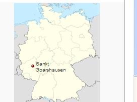
The ship, which overturned near St. Goarshausen, in western Germany, was carrying 2,400 tons of sulfuric acid. Initial measurements carried out downstream from the scene showed no abnormalities and there were no indications that the load was leaking, the shipping office said.

Authorities closed the river to shipping. They were working to secure the 360-foot (110-meter) long tanker, which was floating on its side, and to find the two missing crew members.

The German-owned ship was on its way from Ludwigshafen in southwestern Germany to Antwerp, Belgium.

The accident happened on a picturesque stretch of the Rhine near the famed Loreley cliff.


Wednesday, January 12, 2011

Hezbollah and allies resign, toppling Lebanon government


Hezbollah and allies resign, toppling Lebanon government
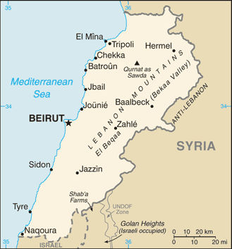
BEIRUT (Reuters) – Ministers from Hezbollah and its Lebanese allies resigned on Wednesday, toppling the government of Prime Minister Saad al-Hariri before expected indictments against the Shi'ite group over the killing of Hariri's father.

Lebanese politicians had said on Tuesday that Saudi Arabia and Syria failed to reach a deal to contain tensions over the U.N.-backed tribunal, which is expected to issue draft indictments soon over the 2005 assassination of Rafik al-Hariri.

The ministers resigned as Saad al-Hariri was meeting U.S. President Barack Obama, and the White House later released a statement criticizing Hezbollah's moves and warning against any "threats or action" that could destabilize Lebanon.

Hariri's office said he left Washington after the talks, heading for Paris to meet President Nicolas Sarkozy on Thursday.

Analysts said the resignations could set the stage for protracted political turmoil in Lebanon.

They played down prospects of a repeat of the violence of May 2008, when gunmen took over Beirut after government moves against Hezbollah. But Sunni power Saudi Arabia, which backs Hariri, warned the resignations "will cause clashes once again."

The Shi'ite Hezbollah has denied any role in the 2005 killing. Its leader, Sayyed Hassan Nasrallah, has attacked the tribunal as an "Israeli project" and urged Hariri to renounce it. The Sunni Muslim premier has resisted Hezbollah's demand.

Announcing the resignations, Christian government minister Gebran Bassil blamed Washington for obstructing the Saudi-Syrian efforts and called on Lebanon's president to "take the required steps for forming a new government."


The Dominican Republic -which shares Hispaniola with Hait


A bit of history of this country, which unlike its neighbor Haiti has the "second largest economy in the Caribbean and Central American region."

The Dominican Republic is a nation on the island of Hispaniola, part of the Greater Antilles archipelago in the Caribbean region. The western third of the island is occupied by the nation of Haiti, making Hispaniola one of two Caribbean islands that are shared by two countries. Both by area and population, the Dominican Republic is the second largest Caribbean nation (after Cuba), with 48,444 square kilometres (18,704 sq mi) and an estimated 11 million people.

Inhabited by Taínos since the 7th century, the territory of the Dominican Republic was reached by Christopher Columbus in 1492 and became the site of the first permanent European settlement in the Americas, namely Santo Domingo, the country's capital and Spain's first capital in the New World. In Santo Domingo stand, among other firsts in the Americas, the first university, cathedral, and castle, the latter two in the Ciudad Colonial area, a UNESCO World Heritage Site.

After three centuries of Spanish rule, with French and Haitian interludes, the country became independent in 1821 but was quickly taken over by Haiti. Victorious in the Dominican War of Independence in 1844, Dominicans experienced mostly internal strife, and also a brief return to Spanish rule, over the next 72 years. The United States occupation of 1916–1924, and a subsequent, calm and prosperous six-year period under Horacio Vásquez Lajara, were followed by the dictatorship of Rafael Leonidas Trujillo Molina until 1961. The civil war of 1965, the country's last, was ended by a U.S.-led intervention, and was followed by the authoritarian rule of Joaquín Balaguer, 1966–1978. Since then, the Dominican Republic has moved toward representative democracy, and has been led by Leonel Fernández for most of the time after 1996.

The Dominican Republic has the second largest economy in the Caribbean and Central American region. Though long known for sugar production, the economy is now dominated by services. The country's economic progress is exemplified by its advanced telecommunication system. Nevertheless, unemployment,[1] government corruption, and inconsistent electric service remain major Dominican problems. The country also has "marked income inequality".

A year later, Haiti celebrates life, mourns its dead

A year later, Haiti celebrates life, mourns its dead
PORT -- AU--PRINCE -- Some people here are marking this painful day in bed, the hurt too much to bear.

By the early hours of the first anniversary of the deadly earthquake that rocked Haiti, Haitians had visited individual tombstones and passed by mass graves, where hundreds of tiny wooden crosses mark the spot where tens of thousands of Haitians are buried.

Many united in prayer.

On the Champs de Mars survivor camp, thousands of Protestants gathered as pastor after pastor exhorted worshipers to ``celebrate life'' amid praises of ``hallelujah.''

A year ago Wednesday, a 7.0 earthquake killed a city's worth of people; the government here estimates as many as 300,000. Their names have not been logged, and some are still under rubble.

About 810,000 people they left behind still are homeless from that day's devastation. But on Wednesday, Haiti's 10 million survivors declared a national holiday to take the time to remember, to say goodbye to the ones they lost and thank you for the lives they still have.

A variety of activities were planned, including an appearance by former U.S. President Bill Clinton.

As a political commentary.... why are these people still homeless? Billions of dollars in aid were donated to this country in the last year (to say nothing of the billions of dollars that have been spent on them in the last decade). Perhaps its time to stop praying to a god who never answers, and start doing some work.

Anyway, where's Haiti:


Note that Haiti shares the same overarcing island of Hispaniola with the Dominican Republic.

Haiti is situated on the western part of Hispaniola, the second largest island in the Greater Antilles. Haiti is the third largest country in the Caribbean behind Cuba and the Dominican Republic (the latter shares a 224 mile border with Haiti). Haiti at its closest point is only about 45 nautical miles (52 mi) away from Cuba and has the second longest coastline (1,100 mi) in the Greater Antilles, Cuba having the longest. Haiti's terrain consists mainly of rugged mountains interspersed with small coastal plains and river valleys.

The northern region consists of the Massif du Nord (Northern Massif) and the Plaine du Nord (Northern Plain). The Massif du Nord is an extension of the Cordillera Central in the Dominican Republic. It begins at Haiti's eastern border, north of the Guayamouc River, and extends to the northwest through the northern peninsula. The lowlands of the Plaine du Nord lie along the northern border with the Dominican Republic, between the Massif du Nord and the North Atlantic Ocean. The central region consists of two plains and two sets of mountain ranges.

The Plateau Central (Central Plateau) extends along both sides of the Guayamouc River, south of the Massif du Nord. It runs from the southeast to the northwest. To the southwest of the Plateau Central are the Montagnes Noires, whose most northwestern part merges with the Massif du Nord. Its westernmost point is known as Cap Carcasse.

The southern region consists of the Plaine du Cul-de-Sac (the southeast) and the mountainous southern peninsula (also known as the Tiburon Peninsula). The Plaine du Cul-de-Sac is a natural depression that harbors the country's saline lakes, such as Trou Caïman and Haiti's largest lake, Lac Azuei. The Chaîne de la Selle mountain range – an extension of the southern mountain chain of the Dominican Republic (the Sierra de Baoruco) – extends from the Massif de la Selle in the east to the Massif de la Hotte in the west. This mountain range harbors Pic la Selle, the highest point in Haiti at 8,793 ft.

The country's most important valley in terms of crops is the Plaine de l'Artibonite, which is oriented south of the Montagnes Noires. This region supports the country's (also Hispaniola's) longest river, the Riviere l'Artibonite, which begins in the western region of the Dominican Republic and continues most of its length through central Haiti and onward where it empties into the Golfe de la Gonâve. The eastern and central region of the island is a large elevated plateau. Haiti also includes various offshore islands.

The historically famous island of Tortuga (Île de la Tortue) is located off the coast of northern Haiti. The arrondissement of La Gonâve is located on the island of the same name, in the Golfe de la Gonâve. Gonâve Island is moderately populated by rural villagers. Île à Vache (Cow Island), a lush island with many beautiful sights, is located off the tip of southwestern Haiti. Also part of Haiti are the Cayemites and Île d' Anacaona.

A bit of history>Haiti (pronounced Hay-tee]), officially the Republic of Haiti is a Caribbean country which occupies the western, smaller portion of the island of Hispaniola, in the Greater Antillean archipelago, which it shares with the Dominican Republic. Ayiti (land of high mountains) was the indigenous Taíno or Amerindian name for the mountainous western side of the island. The country's highest point is Pic la Selle, at 8,793 ft. The total area of Haiti is 10,714 sq mi and its capital is Port-au-Prince. French and Haitian Creole are the official languages.

Haiti's regional, historical, and ethnolinguistic position is unique for several reasons. It was the first independent nation in Latin America and the first black-led republic in the world when it gained independence as part of a successful slave rebellion in 1804. Despite having common cultural links with its Hispano-Caribbean neighbors, Haiti is the only predominantly Francophone independent nation in the Americas. It is one of only two independent nations in the Americas (along with Canada) that designate French as an official language; the other French-speaking areas are all overseas départements, or collectivités, of France.

Haiti is the poorest country in the Americas as per the Human Development Index. It has experienced political violence throughout its history. Most recently, in February 2004, an armed rebellion forced the resignation and exile of previous President Jean-Bertrand Aristide, and a provisional government took control with security provided by the United Nations Stabilization Mission in Haiti (MINUSTAH). Rene Preval, the current president, was elected in the Haitian general election, 2006.

On January 12, 2010, a 7.0 magnitude earthquake struck Haiti and devastated the capital city, Port-au-Prince. Although the exact number was difficult to determine, reportedly more than 230,000 people were killed. The Presidential palace, Parliament and many other important structures were destroyed, along with countless homes and businesses, leaving many homeless.

Tuesday, January 11, 2011

Aid workers rush to help Ivory Coast refugees flooding into Liberia

Monrovia, Liberia
Aid workers are rushing to accommodate the more than 22,000 refugees who have fled Ivory Coast for neighboring Liberia since a disputed election on Nov. 28 left the country on the brink of civil war.

Concerns about Ivory Coast election prompt unexpectedly strong foreign response Ivorians have been streaming across the Liberian border at a rate of roughly 500 per day since Dec. 1, according to the UNHCR, the UN refugee agency that is leading the effort to build a camp to house them. Nearly two thirds of the registered refugees are under the age of 18.

For the past eight weeks, villagers in eastern Liberia have taken in the refugees, squeezing them into their homes and sharing their provisions. But with so many extra mouths to feed, supplies of food and water are running short, UNHCR spokeswoman Fatoumata Lejeune-Kaba said.

Liberia is located to the west of the Ivory Coast.

Where is the Ivory Coast (Cote d'Ivoire)?


History of trhe Ivory Coast
The Republic of Côte d'Ivoire, commonly known in English as Ivory Coast, is a country in West Africa. It has an area of 322,462 km2, and borders the countries of Liberia, Guinea, Mali, Burkina Faso and Ghana; its southern boundary is along the Gulf of Guinea. The country's population was 15,366,672 in 1998, and was estimated to be 20,617,068 in 2009.

Prior to its colonization by Europeans, Côte d'Ivoire was home to several states, including Gyaaman, the Kong Empire, and Baoulé. There were two Anyi kingdoms, Indénié and Sanwi, which attempted to retain their separate identity through the French colonial period and after Côte d'Ivoire's independence. An 1843–1844 treaty made Côte d'Ivoire a "protectorate" of France and in 1893, it became a French colony as part of the European scramble for Africa.

Côte d'Ivoire became independent on 7 August 1960. From 1960 to 1993, the country was led by Félix Houphouët-Boigny. It maintained close political and economic association with its West African neighbours, while at the same time maintaining close ties to the West, especially to France.

Since the end of Houphouët-Boigny's rule, Côte d'Ivoire has experienced one coup d’état, in 1999, and a civil war, which broke out in 2002. A political agreement between the government and the rebels brought a return to peace. Côte d'Ivoire is a republic with a strong executive power invested in the President. Its de jure capital is Yamoussoukro and the biggest city is the port city of Abidjan. The country is divided into 19 regions and 81 departments. It is a member of the Organisation of the Islamic Conference, African Union, La Francophonie, Latin Union, Economic Community of West African States and South Atlantic Peace and Cooperation Zone.

The official language is French, although many of the local languages are widely used, including Baoulé, Dioula, Dan, Anyin and Cebaara Senufo. The main religions are Islam, Christianity (primarily Roman Catholic) and various indigenous religions.

10 Dead, 78 Missing in Australian Flash Floods

Australia is a big continent, and hopefully everyone knows where it is, but exactly where are these flash floods taking place?
BRISBANE, Australia -- Greg Kowald was driving through the center of Toowoomba when a terrifying, tsunami-like wall of water roared through the streets of the northeast Australian city.

Office windows exploded, cars careened into trees and bobbed in the churning brown water like corks. The deluge washed away bridges and sidewalks; people desperately clung to power poles to survive. Before it was over, the flash flood left at least 10 dead and 78 missing.

"The water was literally leaping, six or 10 feet into the air, through creeks and over bridges and into parks," Kowald, a 53-year-old musician, told The Associated Press on Tuesday. "There was nowhere to escape, even if there had been warnings. There was just a sea of water about a kilometer (half a mile) wide."

The violent surge in Toowoomba brought the overall death toll from weeks of flooding in Queensland state to 20, a sudden acceleration in a crisis that had been unfolding gradually with swollen rivers overflowing their banks and inundating towns while moving toward the ocean. Queensland Premier Anna Bligh said there were "grave fears" for at least 18 of those missing.


So, where's Queensland?
It's the area in orange in the map below:

Queensland, a state of Australia, occupies the north-eastern section of the mainland continent. It is bordered by the Northern Territory to the west, South Australia to the south-west and New South Wales to the south. To the east, Queensland is bordered by the Coral Sea and Pacific Ocean. The state is Australia's second largest by area, following Western Australia, and the country's third most populous after New South Wales and Victoria.

As you can see from the map below, Towoomba is located in the southeast corner of the state.